Summary:
The Greenbelt in Eagle and the open space surrounding it is an incredibly valuable resource that can continue to provide benefits to all the citizens and businesses of Eagle for generations to come, if it is treated wisely. The City of Eagle’s Comprehensive Plan recognizes this value and provides guidelines that will enhance its value into the future. I look at specific steps that should be taken in the Comprehensive Plan to make sure that it continues to be a regional draw and a center for community life.
What the City Of Eagle web site says about its city:
Eagle is a uniquely beautiful, friendly and family-oriented community nestled in the Boise foothills.
Our surprisingly mild climate encourages outdoor activities year-round. You can enjoy: fly fishing in the spectacular Boise River, strolling or biking along the Boise River greenbelt...
Top Ten places to live:
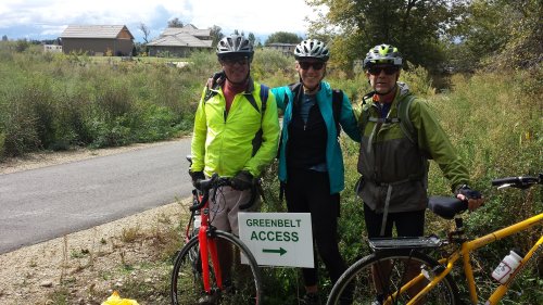
Eagle is a suburb of the state capital, Boise. Running through the city is the Boise River, and just a couple miles away is one of the area’s most popular recreational spaces, the Greenbelt, a 25-mile green pathway that runs along the water’s edge.
Actually, the Greenbelt is right there in Eagle. In fact, it is at its most spectacular in Eagle.
The Eagle Greenbelt draws tourists to Eagle and provides a source of recreation and relaxation for Eagle residents, as well as a safe and quiet commuting route off State Street.
The City of Eagle Comprehensive Plan can be found here.
In its chapter on Parks, Recreation and Open Spaces it states (I have excerpted sections especially relevant to the Greenbelt):
Eagle’s natural features, the foothills, floodplains of the Boise River, Dry Creek and other natural areas are treasured by the community and require protection. These natural open-space features help buffer floods, purify air and water, provide recreational and educational opportunities and reinforce the distinctive character of the community.
Ada County, in cooperation with the City of Eagle, is working on developing an 85-acre community park. The Idaho Department of Parks and Recreation operates Eagle Island Park, a 535-acre regional park designed primarily for wildlife appreciation and swimming.
The City of Eagle values its river, creeks, canals, and foothills. Opportunities for the City include maintaining drainage and canal corridors and rights-of-way to establish a pathway system.
These areas are the habitat of a variety of species (e.g., fish, eagle, etc.) and play an important role in the community’s ecology.
PARKS
Goal
A. To create ample areas and facilities for our residents’ diverse indoor and outdoor park and recreational interests.
Objectives
A. To develop parks and recreational programs which meet the different needs, interests, and age levels of our residents in both the rural and urban areas.
B. To plan and design parks for sustainability and conservation of natural resources.
C. To provide a system of neighborhood parks where safe and convenient access is available to residents.
D. Provide a system of interconnected parks, trails and open spaces throughout the City.
Implementation Strategies
A. Develop policy to preserve, in perpetuity, established parks and land acquired for parks.
PATHWAYS AND GREENBELTS
Greenbelts are typically land areas that border scenic features or hazard areas (i.e. the Boise River and Dry Creek) and are designed to prevent undesirable encroachment. Greenbelts may include pathways and/or bike lanes.
Objectives
A. To create a pathway system that reflects desire to have a pedestrian and bicycle friendly community.
B. To provide a network of central and neighborhood paths where residents are able to safely access and utilize pathways for alternative forms of transportation.
G. Improve/provide access to greenbelt/pathway east of Eagle Road on the south side of the North Channel of the Boise River.
H. Acquire pathway easements on the north side of the North Channel.
I. Consider the pathway easements along drainage ditches.
J. Identify connections between trail sections and existing and future parks and open spaces.
K. Provide adequate parking and public facilities along greenbelts and pathway systems.
L. Link existing isolated pathway segments (e.g., North Channel Center and by-pass path).
M. Provide public information on safety, current location, nearest public facility location, and emergency telephone system along greenbelts and pathway systems (i.e., milepost markers).
N. Work to involve Ada County in implementation process of greenbelts and pathway systems.
O. Provide separate and safe pathway crossings for Highways 55 and 44 at key pathway intersections
Implementation Strategies
Construct bridges to provide access to existing and future greenbelt and pathway system easements.
E. Consider overlay pathway easements for section of canal system in urbanized segment of canal corridor for cooperative multi-use (e.g., section of Farmer’s Union Canal between Horseshoe Bend Road and Floating Feather).
F. Prioritize greenbelt and pathway development: 1) greenbelt/pathway system along the Boise River; 2) greenbelt/pathway system along the Dry Creek; 3) corridor preservation along future planned pathways and irrigation features; and 4) road crossings
OPEN SPACE
Open space is land which is not used for buildings or structures and offers opportunities for parks, recreation, water amenities, greenbelts, river trails and pathways, tourism, leisure activities, viewpoints, and wildlife habitat.
Goal
A. To provide wherever possible open space and natural features such as natural river frontage, greenbelts, river trails and pathways, creeks, flood plains and flood ways, drainage ways and canals, development buffers, wooded areas, grasslands, foothills, and viewpoints for public use and enjoyment.
Objectives
A. To establish open space to protect the finite resource base of Eagle’s natural environment - air, ground water, surface water, soil, forested areas, plant and wildlife habitats, agricultural lands, and aquifer recharge, watersheds, and wetlands.
B. To provide an open space setting for active and passive recreation for all age groups throughout the community.
C. To protect against hazards that are inherent to flood plains, flood ways, steep slopes, and areas of geological instability.
D. To protect the natural lay of the land (e.g., minimize land disturbance).
E. To protect such unique environmental areas as historical, geological, and archaeological sites and monuments, natural areas, and wildlife habitat.
F. To protect important views, vistas, and panoramas of the community’s natural setting and environment.
The whole chapter is well worth a bit of study.
The Land Use chapter makes the follow relevant points:
The Land Use Map is an integral part of the Comprehensive Plan. It serves as a planning policy document and planning tool that will assist the City in sustaining responsible growth and development to ensure that evolving land use patterns remain consistent with goals, objectives and strategies of the Plan.
We’ll get to the Future Land Use Map soon enough as it is the key document.
Residents of Eagle and its AOI have a strong desire to maintain the rural “feel” of the community.
Head of Eagle Island – Special Use Area
The head of the Eagle Island possesses a recognized function as a wildlife habitat, floodway and scenic natural resource reflective of Eagle's rural character. This area is to remain open to the sky and to the mountains to protect the unique environmental and natural features, wildlife habitat and natural lay of the land. The development of streets, buildings and other covered structures within this area should be prohibited.
Land Use Objectives
A. To encourage the conservation and preservation of open spaces, sensitive habitat for plant and wildlife species, and unique areas based on diverse values within the City of Eagle
B. To encourage development with decreasing density radiating out from Downtown Eagle as shown on the Land Use Map.
M. Protect farm- related uses and activities from land use conflicts or from interference created by residential, commercial, or industrial development. Promote the Idaho Right To Farm Act.
River Plain Residential Area
Open space and trail located adjacent to the river in conjunction with the continuation of the regional trail system;
Setbacks from streams, irrigation and drains for trails and open space;
A pathway and trails network should be encouraged to provide pedestrians/bicycle access along the Boise River corridor and from that corridor north into the Moon Valley Area and south into the higher density residential area.
This chapter is the most extensive one of the Comprehensive Plan and provides specific details for development throughout all the different areas of Eagle. I have just excerpted a small portion of the discussion found there that pertains directly to the Greenbelt.
In addition, the Natural Resources and Hazard chapter has material pertinent to the Greenbelt, which I won’t excerpt here, but which you can easily find in the chapter.
What’s to be done?
Given this background what adjustments do I suggest that the City of Eagle make to its Comprehensive Plan and Future Land Use Map to ensure the continued viability and attraction of its Greenbelt? From the Future Land Use Plan:
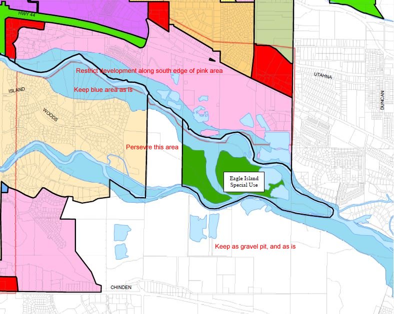
1. Leave significant open space on the north side of the Boise River west from Garden City to Eagle Road. Restrict development to only along State Street, as much as possible. The Open Space provides for a more rural and natural experience in the midst of an urban area. The vistas to the foothills are spectacular. The less residential or other development here, the better.
2. Leave the farm and eastern area of the island as is and open to recreation is much as it is presently (work with Ada County on this).
3. Maintain gravel trails as they are presently, don’t pave.
4. Widen the trail on the south side of the Boise River to Eagle Road around the Laguna Point development. Provide signage.
I have not addressed the area west of Eagle Road (although there is some discussion of it in the Land Use chapter). Essentially the area along the river there should be seen as a continuation of the Eagle Greenbelt in cooperation with Ada County and the State Parks and Recreation Department. This, of course, can continue all the way west to the Snake River.
I have concentrated on a highly used urban area that provides a rural amenity and is greatly enjoyed by many Eagle, Garden City and Boise residents now and will be in the future. Of course, expansion west will be welcomed as population growth occurs in that direction.
I hope that you find these comments helpful and stimulating.
Davis Straub
Boise, Idaho
https://OzReport.com